Council Master Data View
A trusted, read-only view of approved Council information. The Hub is not another GIS map viewer — it explains the data behind the map, who owns it, how fresh it is, and where records disagree.

How this stands apart from MapThat
Council Source Systems
Existing systems remain responsible
Illustrative demo figures — final counts subject to source-system confirmation
Central Data View
Connects, compares and explains
No direct editing of source systems
Users and Outcomes
Role-based views and reporting
Key principles
Recent correction workflow
Data quality summary
Core demo flow
Map View
What can I search?
Click points for linked records. The map is used as evidence to understand location and relationships; the Master Record explains source, owner, freshness and conflicts.
Connected Map Evidence
Shows how source records can be connected by location, overlap, UPRN, references and map evidence. If no record is loaded yet, the button will create one demo evidence record.
Important: Location helps connect records, but the map is evidence — not final proof. The source owner still confirms whether the connection is correct.
Capture results
Capture checks uploaded asset coordinates. It only captures points from layers that are switched on in Layer Manager.
Layer manager
Layers are grouped by service area and start closed. Click the arrow or group heading to open each group. Point clusters are enabled, so overlapping points or zoomed-out points can show a count. Each layer shows its source owner, record count, icon and colour. Use sample points to test layers that do not yet have data.
Master Property / Asset Record
Import spatial file
Import KML or GeoJSON directly. Imports default to Uploaded Data, not General Fund / Property. For Shapefile, upload a .zip containing the .shp, .shx, .dbf and .prj files. Shapefile import needs the online shpjs library to load.
| Asset ID | Address | Layer | UPRN | Title | Service | Confidence | Action owner | Status |
|---|
SQL Connection
The safe design is browser → approved API / middleware → SQL reporting view. This avoids putting SQL credentials in the app.
SQL Database Connection
For a live version, the browser should not connect directly to SQL Server. It should connect to an approved API or reporting view, and that service connects securely to SQL.
Configure SQL/API connection for this prototype
Source Contacts & Updates
The Central Hub can show linked data, but the source owner remains responsible for correcting and approving their own records.
Source ownership and contact details
Source contacts are grouped like the Layer Manager and start closed. Open each group to update owner, email, telephone, review date and status. These details are stored in this browser for the prototype.
Why this matters
Data Accuracy & Ownership Responsibility
The map, dashboards and reports are only as reliable as the source data behind them. Good data must be owned, checked and signed off by the correct service owner.
Key message
What the data owner is responsible for
What the GIS / mapping team is responsible for
X/Y coordinates can provide spatial evidence
The Central Hub does not always need a UPRN to find a possible connection. If a source record contains X and Y coordinates, the Hub can place it on the map and check which property or land boundary it falls within.
For example, an FM record may not have a UPRN, but its coordinates may fall inside a General Fund asset polygon. The Hub can then show that the records are likely to relate to the same location.
This is recorded as a spatial match, not an automatically confirmed match. The evidence shows whether the point is inside the boundary, its distance from the boundary and the confidence of the connection. A data owner can then review and confirm it where necessary.
Especially useful for: land, garages, open spaces and other assets without a normal postal address or UPRN. UPRNs are still used where available; X/Y gives the Hub another reliable way to find possible links.
See how an X/Y spatial match works
Choose a scenario to see the evidence and the action the Hub should take.
The Hub proposes the link and keeps the matching method visible. The source owner reviews and confirms it where required.
Correct change process
Why this matters
Some records may look wrong, incomplete or unusual for a valid reason. Ownership history, legal records, leases, maintenance responsibility, estate boundaries and service decisions can all affect what the data means.
Changes should not be made just because something appears wrong on a map. The source owner must confirm the reason and approve any change first.
Map Display Sign-off
How the data is displayed can change how people understand it. Colours, symbols, labels and layer names should be agreed with the source data owner before publishing.
The GIS / mapping team should publish the agreed map display, but the data owner should sign off the meaning, colours and classification before it is treated as approved.
Simple rule
Map Layers & Data Freshness
This page explains the basic types of GIS layers, common file formats, and the difference between live data and snapshot data.
Simple picture guide
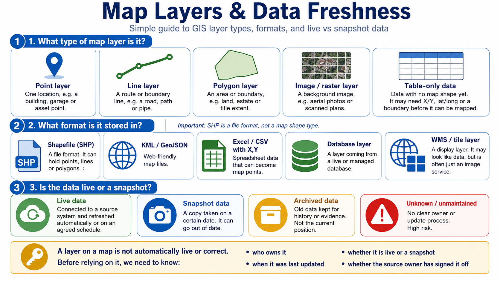
1. What type of map layer is it?
2. What format is it stored in?
3. Is the data live or a snapshot?
Key message
A layer on a map is not automatically live or correct.
Before relying on it, we need to know who owns it, when it was last updated, whether it is live or a snapshot, and whether the source owner has signed it off.
How Records Connect
It looks for stronger proof that two records are talking about the same property, land, building, garage or legal record.
The simple version
Why address is not enough
10 Example Road could mean the whole building, one flat, a garage block, a piece of land, a maintenance area, or a legal title.
So the address helps us search, but it does not prove the records are the same thing.
Better proof of connection
What management needs to know
The key message
The Central Hub is not guessing. It shows the evidence for each connection and highlights where Council source data needs to be confirmed, corrected or improved.
Record Matching & Data Conflicts
It checks UPRN, address, title, asset reference, X/Y, lat-long, geometry overlap and service references such as FM, Housing, Garage and Legal refs.
Why an address is not enough
Different Council systems may use the same address to mean different things. The Central Hub should show this clearly instead of joining records together just because the wording looks similar.
Simple example
These records may all show the same address, but they are not necessarily the same asset.
Connection Readiness / Unlinked Sources
Some source systems cannot be fully connected until they contain a reliable common key. This helps management see where source data needs improving.
| Source system | Link status | Missing or weak key | Plain English explanation | Possible fix | Owner |
|---|---|---|---|---|---|
| FM database | Partly connected | No UPRN / weak address link | FM may know the building, but not the exact Council asset record. | Match by building ref, address, UPRN or X/Y. | FM / Facilities |
| Legal leases | Partly connected | No UPRN or map boundary | Legal may hold a lease or title reference but not a clean map link. | Link by title number, lease ref, address and polygon. | Legal / Property |
| Legacy plans | Not linked yet | No coordinates | A scanned plan may show land, but the Hub cannot place it on the map until it is digitised. | Georeference plan and create polygon. | John Roberts |
| Garages | Partly connected | Missing UPRN / mixed addresses | A garage site may not have a normal property address. | Link by garage ref, asset ref, site address or geometry. | John Roberts |
| Housing records | Possible match | Different address wording | Housing may describe flats, blocks or estates differently to LLPG/SNN. | Check parent/child property relationship and UPRN. | Housing / SNN |
| Old asset spreadsheets | Needs review | No unique ID | A spreadsheet may have a useful description but no reliable key to prove the match. | Create asset reference and match manually. | Source owner |
Master Link Index flow
Connection checks
| Connection method | Status | Evidence | Owner |
|---|
Conflict summary
How references can connect through source systems
Connection Path Explorer
This page explains why a record is connected, what key was used, and where the link may be weak or missing.
Path used to connect
Why this connection is used
What could be wrong
Common connection routes
Data Flow & Transformation Map
This is a simplified FME-style view. It shows the main routes into the Master Link Index, where data may be transformed, and where missing or conflicting values are flagged.
Connection flow
Source systems
Extract and transform
Master Link Index
Outputs
Key transformation routes
Where the flow can fail
Manager-friendly message
The Hub does not just join records because they have the same address. It checks stronger links first, shows where the link is weak, and routes missing or conflicting information back to the source owner.
Simple rule example
Discrepancies and Data Quality Checks
Source ownership matrix
| Data item | Source of truth | Owner |
|---|
Issue owner / action routing
| Issue | Action owner | Action |
|---|
Report discrepancy / correction form
Open correction requests
Before: manual checking
- Check Dynamic Maps / GIS layer.
- Search Land Terrier / GF records.
- Check LLPG / SNN for UPRN/address.
- Check Land Registry separately.
- Ask FM, Housing or Legal for extra records.
- Manually decide whether records match.
After: Data Views
- Click one asset or map point.
- Index checks Asset ID, UPRN, address and title.
- Linked records display together.
- Confidence, source of truth and action owner shown.
- Issue routed to correct data owner.
- Audit trail records changes.
Database
- SQL Server / Azure SQL
- Spatial geometry support
- Master Asset Index
- Audit/refresh tables
Data feeds
- Read-only source views
- FME / SQL jobs / APIs
- Approved field lists
- Refresh schedules
Security
- Role-based access
- Restricted legal/housing fields
- Internal hosting
- Audit logging
GIS
- Real polygons
- Coordinate points
- Layer manager
- MapThat/OpenLayers/Leaflet
Help / Guidance
These pages are useful for explaining the background, but they sit behind the main workflow so the app does not feel like a training manual.
Supporting pages
Main demo message
One selected asset. Connected source records. Visible owner, source, freshness and conflicts. The map supports the evidence, but corrections go back to the responsible source owner.
Settings / Import
This prototype stores records in localStorage. Use backup/import to move test data between browsers.
Upload .xlsx, .xls or .csv. You choose the coordinate system during upload. Use EPSG:27700 for Easting/Northing, or WGS84 for Longitude/Latitude.